Eagles over Kidsty Pike
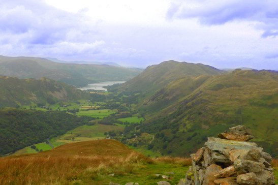
Patterdale and Ullswater from Hartsop Dodd
Late August, time for a further return to the Lakes. The weather looked settled so Luna and I headed to the Far Eastern Fells, the closest to home. I’m also looking for the most effective way of completing my remaining 59 summits after closing the book on the North Western Fells. Heading out from Hartsop was such a good choice, it took me into an area I had rarely visited and could head over to Kidsty Pike, the next remaining highest on my list.
Its taken me a while to do this blog, not least because after completing it on my tablet while away in Dubai, WordPress lost the whole thing. Learning point, its doesn’t auto-save from the app. That wasted a days blogging effort and I lost heart for a while.
Anyway, back to a month ago; we parked beside the ford in the village, the first parking spot available and looked good for a dog wash at the end of the day. First objective was Hartsop Dodd, Wainwrights guidebook recommendation is to take the North ridge, but unusually he doesn’t give an ascent plan. He suggests using a path from Brothers Water, now the Access Area, so that’s were we headed. Head-high bracken forced us into the adjoining field good for a while, but soon confronted by the barbed wire fell fence, with no gate or stile. Getting Luna across walls and fences is not easy, she can jump 1 metre easily, but with a clear takeoff and landing.. not here on a steep slope. So it was time for an ungainly heft.
After that extra we soon picked up the groove path straight up the ridge. Looking down the fell one can see the possibility of a path heading from Hartsop car park and along the fell wall, and up to the ridge. A later look later at the fine detail of the 1:25,000 map shows that path, but it does need magnification. This groove path took us straight to the summit, a small cairn built from the fell wall which is really the high point. Great views across to Dovedale and up Patterdale to Ullswater. Two great drawings in the guidebook capture the view but not the autumn colours of course.
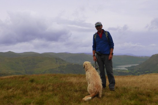
Luna enjoying the view up Dovedale. Hartsop Dodd #156
Heading up the fell wall, a large bird of prey appeared from the East, glided over the ridge and dropped down into Caudale before flying across to Dovedale. This is the area where the Lake District eagles lived, but apparently have not been seen for a year. A search in the bird forums suggest this could have been a buzzard, which nest on Raven crag in the cove below this ridge. I have to say it looked far bigger than a buzzard, which I do see most days on the moors at home. I’ll put it down to a Golden Eagle sighting, but will have to remain unconfirmed.
This ridge led up to Caudale Moor and Stoney Cove Pike, a flat area at the head of four coves. Not an interesting summit nor really a pike even when viewed from below. An interesting aside, it’s also referred to as John Bells Banner. Strange name for a fell; research suggests it’s not my brother-in-law John Bell but a member of the local fox hunt who used to sit on this fell to turn back the fox. A job unlikely to be needed these days..
After lunch we headed off down the easy scramble into Threshthwaite Mouth, the terrain starting to feel more like the higher Lake District fells. A short pull up the other side took us onto more familiar ground, Thornthwaite Crag, the high point on the Kentmere Round. The shapely tops of Ill Bell and Froswick formed the horizon, but in this overcast weather, there was not much colour in the familiar views.

Ill Bell and Froswick, on the Kentmere Round
A gentle walk along the old race course and Roman road along High Street took us to the Straits of Riggingdale, a wonderful name for the col below Rampsgill Head. This head is another summit surrounded by four steep coves, each with edges and deep valleys. My route swung around above above Twopenny Crag towards Kidsty Pike, the rocks make a useful break in the grass to provide a bit of a foreground to a photo.

Kidsty Pike over Twopenny Crag
This is a real pike, having a rock face dropping into Riggindale. This gives its the familiar feature from the east, a recognisable summit from Shap and the M6. Its east ridge down to Mardale and Haweswater would be a good route before the reservoir was completed. Than, a car park and pub would have attracted more traffic than the lonely waterboard road.

Harter Fell seen over Riggindale Crag from Kidsty Pike
Back over Rampsgill, I made sure this was a confirmed completion on my list. I had previously done a Wild Camping trip up here, starting from Howtown. I don’t recall why we didn’t take in Kidsty Pike at that time, it did leave a stray summit to be completed at a later date, ie now.
The pa th back down to Hartsop skirts around The Knott and heads down above Hayeswater. This is one of the Fix-the-Fells tracks that seem out of proportion to the traffic they get. Its wide and full of rubble; not pleasant underfoot. Certainly, Saluki paws much prefered the grass edges. This new track disappears before a grassy path headed down to the lake. Here was a good spot to give Luna a good wash in the water, removing all the peat and mud she had got from her investigations away from the paths.
A water board track takes one down easily to Hartsop past the lovely Hayswater Gill. It’s good to see the recent improvements in the path do allow the waterfalls to remain visible and the water flow means they are always in full spate.

An old mine building next to Hayeswater Gill looking up Thresthwaite Cove.
So that was Wainwright fells 156 to 158 on my list completed. I will have to return here soon to finish the remaining tops above the village; Gray Crag and Brock Crags.

Sounded like day with lots of map-reading!
Nice clear day, so apart from the start a generally easy navigation day.