A few photography hints on Derwent Edges

Approaching Back Tor
On top of Lost Lad I chatted to a couple. One asked if I’d taken any good photo’s. I looked around the almost flat horizon and explained that today, on these moors, colours were difficult to find, it’s a bit monochrome. The close terrain is a bit featureless, particularly until one gets to the edges and this overcast sky was mainly the same colour as the peat ground.
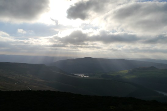
Sun breaking through, looking down to Ladybower Reservoir
And then the sun started breaking through and we had blue sky appearing through dark grey clouds with black and silver edges, bright green forestry around the aquamarine reservoirs below, with many shades of green across the other side of the Derwent valley. Colours appeared as the sun came out.

Looking northeast from Whinstone Lee Tor to Kinder and Bleaklow
 This Sunday had promised clear skies from the start so the overcast morning hadn’t deterred the walkers and cyclists arriving early at Fairholmes. I got the one of the last free parking spots and headed off under the impressive solid stone dam to the east side of the Reservoir. The PNFS signpost pointed the way up through the woods to Strine. Once above the trees most walkers head upwards towards the three Tors at the start of the edge. Howshaw Tor, Lost Lad and Back Tor are great spots, islands in a dull sea of peat and winter heather. Across this higher path the Tors are joined by useful paving stones, such joy avoiding the peat and mud.

This track heads south, keeping to the edge through delightfully named boulders and crags; Cakes of Bread, Dove Stone, Salt Cellar, White Tor. All such fun to explore. I kept on the edge past the usual route back down to Derwent to enjoy a great viewpoint at Whinstone Lee Tor. A high viewpoint north over Ladybower was worth the extra 1/2 km stroll.
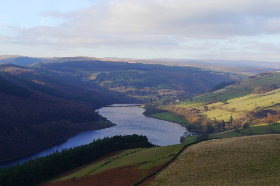
Ladybower, looking towards Fairholmes

Hurst Clough across the water.
By this time in the afternoon the mountain bikers were out in force, pushing their bikes up the hill on the way back to Ladybower or Cutthroat. I do have to record that today they were all so polite and made way for walkers and always thanked when I made way. A change from being charged down by rogue bikers on other hills closer to home.
By now the sky was almost clear and the early winter colours filled the valley. Time to finish off the tea flask and make a timely return home.

Nice day out Tony …. Close to the one we did a year or so ago?
Almost exactly the same route Bill. I recall explaining how your pit zips work and a few crazy panoramas.
Was Rememberance Sunday after Mikes party.